Rio Grande Valley Amateur Radio Club
RGVARC Weather Portal
Current Rio Grande Valley, Gulf, tropical, severe-weather, marine, and preparedness information. Use official NWS and NHC guidance for decisions affecting life or property.
No matching weather products.
Local RGV3 products
McAllen, Texas Forecast
Automatic NWS forecast and active alerts for McAllen, Texas.
Forecast for McAllen, Texas
Current Rio Grande Valley NWS Alerts
Active watches, warnings, and advisories for Deep South Texas and the Lower Rio Grande Valley.

This live image cannot be displayed inside the portal.
Open live productRio Grande Valley Interactive Radar
Interactive weather radar centered on the Rio Grande Valley. Use official NWS warnings for protective decisions.
Severe Weather4 products
Current Severe Weather Watches
Current tornado and severe-thunderstorm watches.

This live image cannot be displayed inside the portal.
Open live productDamaging Wind Probability — Today
Probability of damaging thunderstorm wind within 25 miles.

This live image cannot be displayed inside the portal.
Open live productHail Probability — Today
Probability of severe hail within 25 miles of a point.

This live image cannot be displayed inside the portal.
Open live productTornado Probability — Today
Probability of a tornado within 25 miles of a point.

This live image cannot be displayed inside the portal.
Open live productRadar & Rain5 products
Excessive Rainfall Outlook — Day 1
Risk areas for flash flooding and excessive rainfall.

This live image cannot be displayed inside the portal.
Open live productNational Radar Mosaic
Animated CONUS large-domain radar mosaic.

This live image cannot be displayed inside the portal.
Open live productDay 1 — 24-Hour Rainfall Forecast
WPC Day 1 quantitative precipitation forecast for its fixed 24-hour valid period.

This live image cannot be displayed inside the portal.
Open live productDays 1–5 Rainfall Forecast
WPC accumulated precipitation forecast for Days 1 through 5.

This live image cannot be displayed inside the portal.
Open live productDays 1–7 Rainfall Forecast
WPC accumulated precipitation forecast for Days 1 through 7.

This live image cannot be displayed inside the portal.
Open live productSatellite3 products
Gulf of Mexico Satellite Loop
GOES-East GeoColor loop covering the Gulf of Mexico.

This live image cannot be displayed inside the portal.
Open live productTropical Atlantic Satellite Loop
GOES-East GeoColor loop across the tropical Atlantic.

This live image cannot be displayed inside the portal.
Open live productTropical Atlantic Upper-Level Water Vapor
Upper-level water-vapor satellite loop using GOES-19 ABI Band 8.

This live image cannot be displayed inside the portal.
Open live productAtmosphere5 products
24-Hour Wind Shear Tendency
Change in vertical wind shear over the previous 24 hours.

This live image cannot be displayed inside the portal.
Open live product850 mb Vorticity
Low-level atmospheric rotation.

This live image cannot be displayed inside the portal.
Open live productCurrent Vertical Wind Shear
Environmental vertical wind shear affecting tropical development.

This live image cannot be displayed inside the portal.
Open live productDeep-Layer Steering Flow
Approximate steering flow for deeper and stronger tropical cyclones.

This live image cannot be displayed inside the portal.
Open live productLow-Level Steering Flow
Approximate steering flow for shallow tropical systems.

This live image cannot be displayed inside the portal.
Open live productTropics6 products
Atlantic Tropical Outlook — 2 Days
Official Atlantic tropical cyclone formation outlook.

This live image cannot be displayed inside the portal.
Open live productAtlantic Tropical Outlook — 7 Days
Official seven-day Atlantic tropical cyclone formation outlook.

This live image cannot be displayed inside the portal.
Open live productEastern Pacific Tropical Outlook — 7 Days
Useful for systems that could approach Mexico or cross into the Gulf.

This live image cannot be displayed inside the portal.
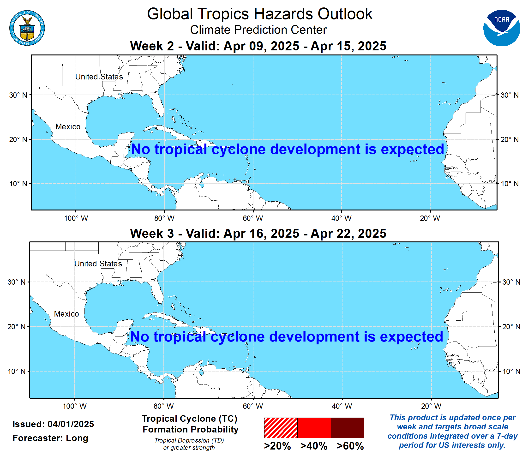
Open live productAtlantic Tropical Cyclone Outlook — Weeks 2–3
CPC Weeks 2–3 outlook for Atlantic tropical cyclone formation potential.
This live image cannot be displayed inside the portal.
Open live productTropical Formation Probability — 24 Hours
Objective tropical cyclone formation probability guidance.

This live image cannot be displayed inside the portal.
Open live productTropical Formation Probability — 48 Hours
Cumulative objective formation probability guidance.

This live image cannot be displayed inside the portal.
Open live productForecast Models3 products
CyclonicWX Tropical Guidance
Tropical cyclone tracks, intensity guidance, and model products.
Tropical Tidbits Model Guidance
GFS, ECMWF, CMC, ICON, ensembles, and other model products.
WeatherNerds Model Guidance
Advanced numerical weather model displays and tropical guidance.
Marine4 products
Atlantic Surface Forecast — 24 Hours
Official 24-hour tropical Atlantic surface forecast.

This live image cannot be displayed inside the portal.
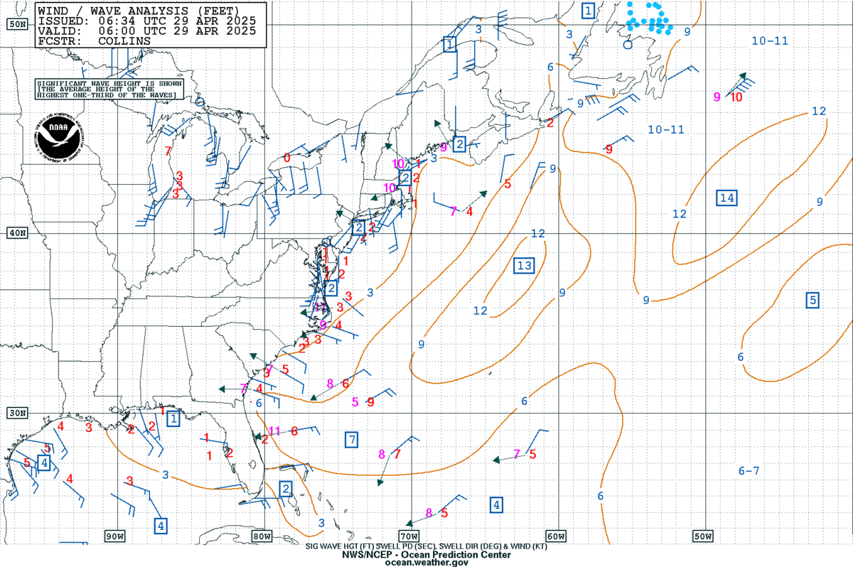
Open live productWestern Atlantic Wind and Wave Analysis
Official western Atlantic offshore wind and wave analysis in feet.
This live image cannot be displayed inside the portal.
Open live productGulf Surface Analysis
Official Gulf surface analysis showing fronts, pressure systems, troughs, and tropical features.

This live image cannot be displayed inside the portal.
Open live productAtlantic, Caribbean & Gulf Significant Wave Heights
Official significant-wave-height analysis covering the tropical Atlantic, Caribbean Sea, and Gulf.

This live image cannot be displayed inside the portal.
Open live productOcean4 products
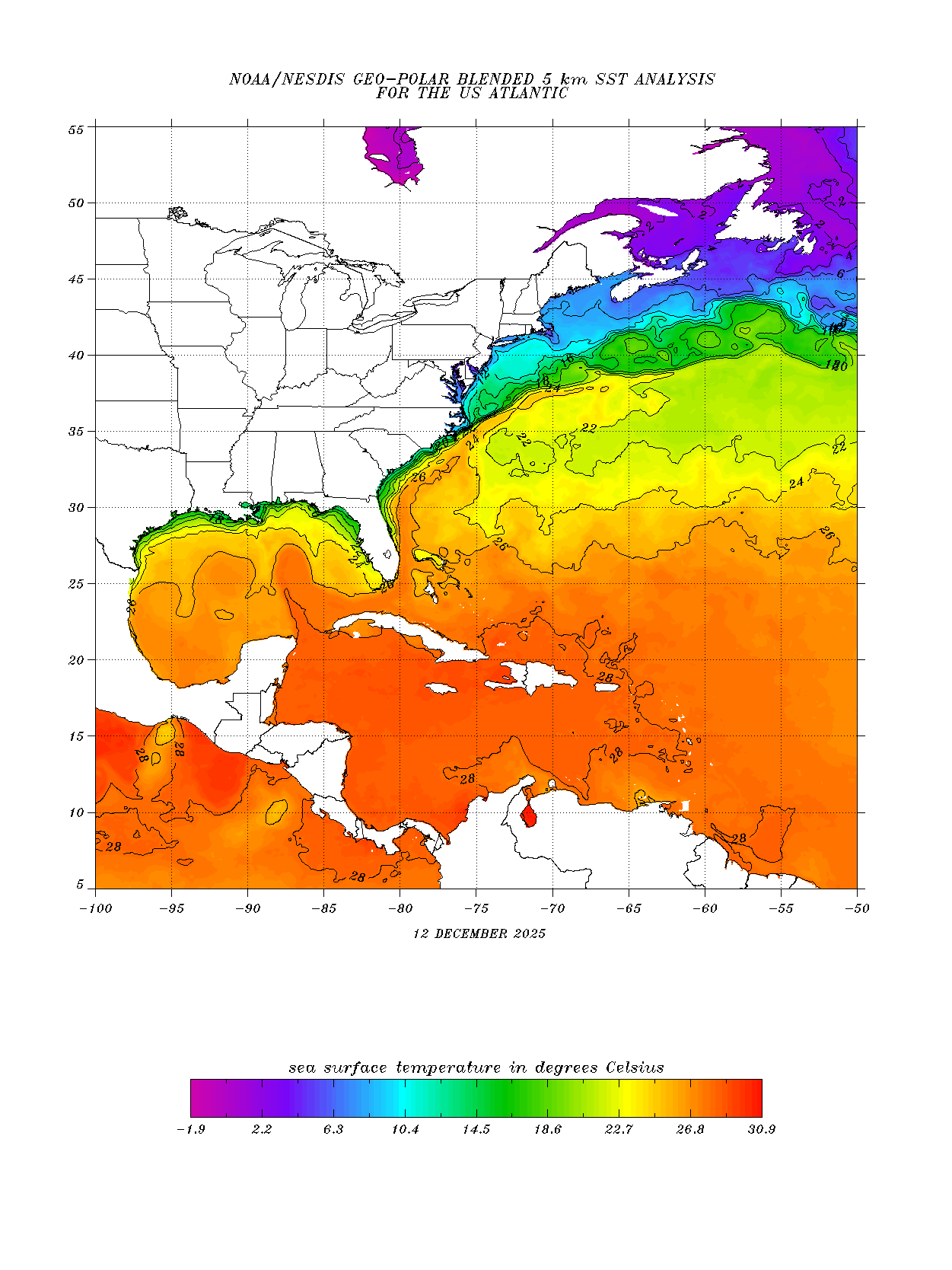
U.S. Atlantic Sea-Surface Temperatures
Current NOAA blended 5 km sea-surface temperature analysis for the U.S. Atlantic.
This live image cannot be displayed inside the portal.
Open live productGlobal Sea-Surface Temperature Anomaly
Current daily 5 km sea-surface temperature departure from the long-term average.

This live image cannot be displayed inside the portal.
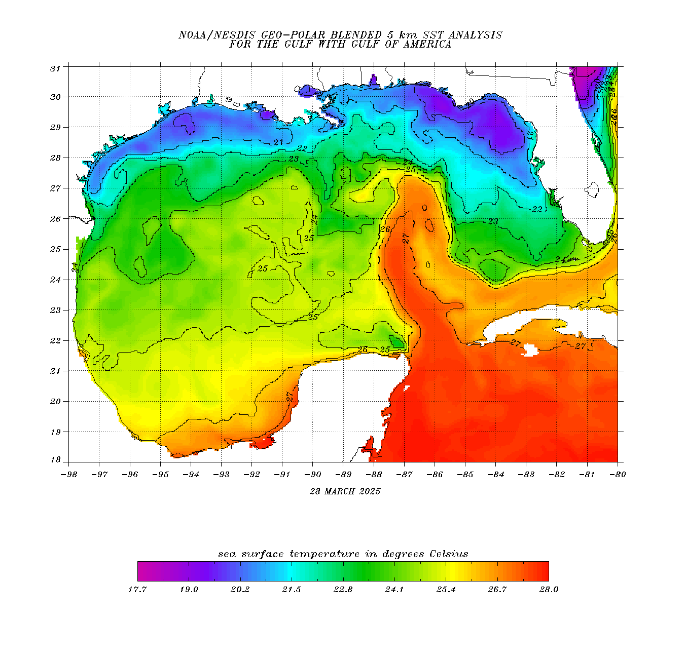
Open live productGulf Sea-Surface Temperatures
Current NOAA blended 5 km sea-surface temperature analysis for the Gulf.
This live image cannot be displayed inside the portal.
Open live productNorth Atlantic Ocean Heat Content
Current North Atlantic upper-ocean heat content used to assess tropical cyclone intensification potential.

This live image cannot be displayed inside the portal.
Open live productInteractive Maps2 products
Interactive Wind, Rain, Pressure, and Models
Interactive forecast map centered on South Texas and the western Gulf.
Live Global Wind Map
Interactive global wind visualization.
Preparedness3 products
Hurricane Preparedness
Official preparedness guidance before, during, and after a hurricane.
NOAA Weather Radio
Find NOAA Weather Radio information and frequencies.
Understand Storm Surge
Storm-surge science, risk, products, and safety information.
Safety notice: This page aggregates automatically updating products. For protective actions, use current instructions from the National Weather Service, National Hurricane Center, local emergency management, and public-safety officials.